I've been messing around with QGIS and old maps of Manchester. My approach at the moment is 'layer as many maps as I can find' and 'add as many different databases as I can' on the map and see what happens. I'll add some contextual and analytical information in another post.
Here's a link to a simple map of Manchester (click on the expander on top right to layer a tile of Green's 1794 map on it), and the addresses of United Englishmen layered on it:
There's a plugin in QGIS called
QGIS2threejs which makes it easy to make elevations and buildings in 3D.
So here's my slightly strange attempt to make Murray's Mills in Ancoats, together with a pub and some terraces, into 3D:
 |
| Murray's Mills, Ancoats, in 3D |
Another plugin allows you to draw cartograms.
Here's a gif comparing a straight map of Manchester police districts, coloured according to their population density in 1831, with a cartogram
(i.e. the areal size and shape of each district is warped according to
the density):
 |
| Cartogram of Manchester population density 1831 |
I'm also attempting to map all 600-odd subscribers to the Chartist Land Plan in 1847 from Manchester and Salford. It's been difficult because many of the addresses are spelled phonetically, are in the bits of Hulme and Chorlton that were obliterated by the Mancunian Way and post-war slum clearance, and also many addresses are courts and passages that are not marked on any map. But here's the current heat-map of addresses (c.400) that I have identified:
 |
| heatmap of Chartist land plan subscribers, 1847, in google fusion tables |
And here is a heatmap (done in QGIS rather than google fusion tables) of cholera deaths & outbreaks in Hulme in 1850, layered on the 1849 OS map. The blue dots are Chartist subscribers.
 |
| Heatmap of cholera outbreak, Hulme, 1850, with Chartist land plan subscribers |
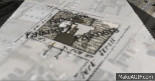
Here's a Gif of my first attempt to reconstruct Falkner's Court, Ancoats, in 3D. The original map is from a cholera report of 1833.


Comments
Post a Comment