Adventures in QGIS continued
I'll do some how to guides on my experiments in QGIS with historical maps soon, but here's an aide memoire of the tutorials I've used:
Creating a heat map:
http://www.qgistutorials.com/en/docs/creating_heatmaps.html
Creating a contour map:
http://www.qgistutorials.com/en/docs/working_with_terrain.html
And to show that I'm just messing around and not doing this systematically, here's my failed experiment to warp geo-referenced maps onto a DEM (elevation) layer:
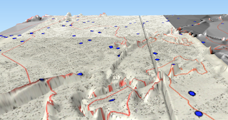 Apparently north Manchester has a mountain range according to this...
Creating a heat map:
http://www.qgistutorials.com/en/docs/creating_heatmaps.html
Creating a contour map:
http://www.qgistutorials.com/en/docs/working_with_terrain.html
And to show that I'm just messing around and not doing this systematically, here's my failed experiment to warp geo-referenced maps onto a DEM (elevation) layer:


Comments
Post a Comment